The Coastal States Organization represents the nation’s Coastal States, Territories, and Commonwealths on ocean, coastal, and Great Lakes resource issues. Having trouble opening links? View this on our website: https://coastalstates.org/resources/ |
|
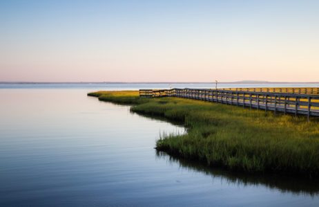
National Estuaries Week September 20-27 |
|
Source: Restore America’s Estuaries |
|
| Starting in 1988, people and organizations across the country have celebrated National Estuaries Day to draw attention to protecting these vital ecosystems. Since then, the celebration has expanded to a whole week, led by organizations such as Restore America’s Estuaries, the National Estuary Program, and the National Estuarine Research Reserve Association. Last year, both chambers of Congress passed resolutions designating September 21-28th, 2024 as National Estuaries week. Through this, a bipartisan group of Representatives and Senators showed their commitment to protecting and restoring America’s estuaries. This year, Restore America’s Estuaries published a report highlighting the economic, environmental, and recreational benefits of our estuaries. The report also detailed how protecting these waters protect infrastructure and fuel economic growth. There are many ways to participate in National Estuaries Week. If you are hosting a restoration project, submit it to be featured on RAE’s 2025 National Estuaries Week Project Map. You can also show your support online with the help of the Social Media Toolkit. The National Estuarine Research Reserve Association also offers many ways to enjoy and support your local Reserve. |
|
| In the States and Territories |
|
| Healey-Driscoll Administration Announces the 2025 COASTSWEEP Beach Cleanup The Healey-Driscoll Administration today announced that Saturday, September 20, is the start of the 2025 COASTSWEEP season. People are encouraged to volunteer at one of the dozens of cleanup events planned along the coast. These events, organized by the Massachusetts Office of Coastal Zone Management (CZM), will run until early November. Since 1987, more than 111,000 COASTSWEEP volunteers have removed more than 1.4 million pounds of marine debris and other trash from Massachusetts beaches, lakes, rivers, and the seafloor. “The Office of Coastal Zone Management is proud to continue the COASTSWEEP tradition that began in 1987,” said CZM Director Alison Brizius. “This work wouldn’t be possible without the countless dedicated volunteers who are committed to keeping Massachusetts’ coast clean and healthy. Here’s to another great year!” COASTSWEEP is part of the International Coastal Cleanup, organized by Ocean Conservancy, and draws hundreds of thousands of volunteers to coastal cleanups in 118 countries worldwide. Read more here. Georgia Department of Natural Resources Looks Inland for Coastal Resiliency Strategies Southern inland counties of Effingham, Long, Wayne, Brantley and Charlton may not immediately come to mind when considering threats to Georgia’s coast. But it’s been clear that recent storm surges and tides do reach these communities, as flooding along roads and rivers has already devastated homes in many of these neighborhoods. And it appears that these events are gaining more attention from the state’s coastal planners. Every five years, the Georgia Department of Natural Resources’ Coastal Management Program (GCMP) develops a section 309 assessment—a strategy to tackle the state’s coastal issues, which is funded by the National Oceanic and Atmospheric Administration (NOAA). In the fall of 2026, the GCMP will begin its new section 309 assessment and is looking to focus its attention west of Georgia’s coastal-facing communities. “The new strategy is intended to shift inland,” said Jan Mackinnon, Coastal Resources Division program manager. The GCMP is looking to update floodplain maps, create a vulnerability assessment, and provide guidance on resilience to local jurisdictions in the inland counties. Read more here. |
| Oil Spill Program Continues Vessel Removal in Texas Waters The Texas General Land Office (GLO) Oil Spill division, in collaboration with the GLO Coastal Resources division, closed out a project to remove another five derelict vessels from Texas coastal waters. The funding for the project came from the National Oceanic and Atmospheric Administration (NOAA) Cycle 28 Texas Coastal Management Program (CMP). CMP awards approximately $2.2 million annually in grants to support natural habitat and wildlife protection efforts. The removal of these vessels comes after the GLO, in coordination with the Gulf of America Alliance (GOAA), supported the removal of five abandoned vessels from South Galveston County totaling approximately 21,040 pounds of debris. The Oil Spill division will initiate another vessel removal project scheduled for late September. Eleven vessels located on state-owned submerged land are planned for disposal from Orange, Chambers, Galveston, Matagorda, Nueces, Willacy and Cameron counties, weather and safety conditions permitting. Read more here. High Groundwater Levels May Increase Damage Risk to Alabama Coastal Roads A new model developed by NCCOS-funded researchers shows that parts of Alabama’s coastal highways are likely to become damaged due to high groundwater levels. Decision-makers across coastal states can use the model’s framework, which incorporates localized rainfall and water level data, to guide and inform adaptive management of coastal roadways. The combined effects of rising sea levels, extreme high tides, storm surges, and moderate to severe rainfall cause groundwater levels to rise, which could compromise road integrity. Over time, high groundwater levels create pressure on underlying roadbeds. Water infiltration into pavement layers can lead to cracks or potholes forming on road surfaces, creating hazards for drivers and resulting in costly road repairs. Model outputs showed that, under predicted sea level rise scenarios and frequent moderate rainfall, some sections of Alabama’s State Route AL-180 roadbed may remain saturated for extended periods. The areas most at risk for deterioration are those with low elevation, chronically high groundwater levels, and heavy vehicle use on wet pavement after rainfall events. AL-180 serves as the main connector from an outlying peninsula to the mainland and is a key hurricane evacuation route, so understanding and identifying potential vulnerabilities may help local transportation engineers minimize hazardous road conditions. Read more here. |
| In Southwest Michigan, Erosion is Taking Away Beaches, Backyards More and More Every Year In Southwest Michigan along the Lake Michigan shoreline, full- and part-time residents are losing more of their backyards every year — and the changing climate and weather patterns are making the problem worse. On average, Southwest Michigan loses more than a foot of shoreline every year. But one specific area lost 75 feet in four years. John Yellich, the retired former head of the Michigan Geological Survey, is behind the first research done on erosion in Southwest Michigan in almost a decade. He fought for the research and funding he fought because of the significant erosion issues tracked in the area. The research into erosion along Lake Michigan brought together Illinois, Indiana, Wisconsin, and Michigan geologists and geography experts. The research focuses on Mount Pleasant in Allegan County, and Miami Park in South Haven, Michigan. Read more here. As Mussels Ravage Great Lakes Whitefish, Lake Superior Survives – for Now Invasive quagga and zebra mussels have destroyed entire ecosystems and killed billions of baby fish in the lower Great Lakes. As a result, lake whitefish are on the brink of collapse. The crisis has rippled through the ecosystem, destroying fishing families’ livelihoods in the process. Lake Superior is the lone holdout in a mussel invasion that has overtaken every other Great Lake, a salvation credited to low calcium levels that stymie mussels’ efforts to build shells, cold water that hinders their reproduction, and relative isolation, which limits the boat traffic that spreads invasive species. But a spate of recent outbreaks, from Isle Royale to Canada’s Nipigon Bay, are testing old assumptions about the lake’s defenses and leaving scientists with an uneasy feeling. In order to slow the spread of this invasive species, Michigan and Minnesota both require boaters to clean aquatic organisms from their boats and trailers and drain all bilges and ballast tanks before launching into a new water body. But compliance and enforcement are both spotty. Read more here. |
| Submarine Groundwater Discharge Fuels Algal Groth, Threatening Coral Reefs in American Samoa New USGS-led research finds that submarine groundwater discharge (SGD)—the unseen flow of freshwater and nutrients from land to sea—is a key driver of water quality and nutrient loading on the island of Ofu, American Samoa, with implications for reef resilience in a changing climate. The corals of Ofu are vibrant, diverse, and unusually tolerant of above-average water temperatures; other researchers have noted that these corals may provide critical insights into the potential of coral acclimatization and adaptation to climate change. However, excess nutrients from groundwater can fuel increased algal growth—which may compete with corals for space and light—potentially undermining the resilience of even thermally tolerant coral species. Using an advanced suite of tools—including drone-based thermal imaging, radon tracing, electrical resistivity surveys, and direct water sampling—USGS scientists quantified how groundwater seeps into two shallow reef pools, Papaloloa and Fattuana, within the National Park of American Samoa on Ofu Island. Understanding groundwater inputs could help managers mitigate nutrient pollution and protect coral habitats critical to biodiversity and local livelihoods. Read more here. First Offshore Wave Energy Project in the U.S. Launches in Los Angeles Along a rocky wharf at the Port of Los Angeles on Tuesday, seven blue steel structures bobbed in the gentle wake of a Catalina Island ferry. The bouncing floaters marked a moment for clean energy — the first onshore wave power project in the country. The floaters belong to Eco Wave Power, a Swedish company behind the pilot project located at AltaSea, a nonprofit ocean institute at the port. They harness the natural rise and fall of the ocean to create clean electricity 24 hours a day. The pilot project can generate up to a modest 100 kilowatts of power — enough for about 100 homes — but company officials said the ultimate goal is to install steel floaters along the port’s 8-mile breakwater to generate about 60 megawatts of power, or enough for about 60,000 homes. Such an achievement could be replicated along other parts of the U.S. coastline, according to Inna Braverman, Eco Wave Power’s co-founder and chief executive. She noted that the U.S. Energy Information Administration estimates that wave power has the potential to provide more than 60% of the country’s energy needs. Read more here. |
| September 18-19, 2025 September 24, 2025 September 30, 2025 October 7-10, 2025 October 21, 2025 October 29-30, 2025 November 9-13, 2025 NOAA Science Seminar Series NOAA Digital Coast Training Calendar Silver Jackets Webinars |
| [NEW] International Coastal Cleanup Day 2025 International Coastal Cleanup (ICC) is one of the world’s largest annual preservation and protection events and volunteer efforts for our ocean, waves and beaches. The cumulative result is not only a cleaner and healthier coastline but also a raised consciousness for accessible actions people can integrate into their lives to promote healthy beaches on a daily basis. This year, International Coastal Cleanup takes place Saturday, September 20th. Learn about opportunities near you here. Funding Opportunity: $1.45 Billion in Supplemental Economic Funding Available for Disaster Recovery The United States Economic Development Administration has announced the Notice of Funding Opportunity (NOFO) for its Fiscal Year (FY) 2025 Disaster Supplemental Grant Program. This program makes approximately $1.45 billion available to areas that received major disaster declarations in the calendar years 2023 and 2024 for economic recovery activities. Funds can support both construction and non-construction projects. State and local governments, Native tribes, higher education institutions, public or private non-profit organizations that work with local government, economic development organizations, and public-private partnerships for public infrastructure are eligible. The EDA will fund up to 80% of the project with higher percentages available for severely distressed applications and Tribal organizations. Applications are accepted on a rolling basis until funds are spent for Readiness and Implementation path projects, while Industry Transformation grants will be due March 3, 2026. For more information, contact Rania Campbell-Bussiere. Funding Opportunity: FWS Coastal Program FY25 The U.S. Fish and Wildlife Service (Service) Coastal Program is a community-based program that helps coastal areas with technical and financial support to address complex conservation challenges of priority coastal ecosystems. This support is mainly provided through cooperative agreements with conservation partners and landowners, including state and Tribal agencies. The goal is to restore and protect fish and wildlife habitats on both public and private lands. Coastal Program staff work with partners, stakeholders, and other Service programs in important areas for conservation. Applications are due September 30, 2025. Learn more here. 2025 National Estuaries Week Photo Contest NOAA’s Office for Coastal Management is hosting a photo contest to celebrate National Estuaries Week from September 20 to 27, 2025. Send them your best photos from the National Estuarine Research Reserves that display the beauty of the reserves, critters that live there, and the people who work and play there. Winners will be chosen by a panel of judges and will be featured in their social media campaign during National Estuaries Week. Learn more here. Funding Opportunity: Fiscal Year 25 Community Assistance Program The Community Assistance Program – State Support Services Element (CAP-SSSE) program provides funding to states to provide technical assistance to communities in the National Flood Insurance Program (NFIP) and to evaluate community performance in implementing NFIP floodplain management activities. Designation, duties and responsibilities of State Coordinating Agencies are found in 44 CFR 60.25. These regulations identify the states commitment to the minimum floodplain management criteria and to demonstrate the capability and responsibility to implement the program. In this way, CAP-SSSE helps to; ensure that the flood loss reduction goals of the NFIP are met, build state and community floodplain management expertise and capability, and leverage state knowledge and expertise in working with their communities. Learn more here. |
|
| The views expressed in articles referenced here are those of the authors and do not represent or reflect the views of CSO. If you have a news item or job posting to include in future CSO Newsletters, please send an email to: ecrocco@coastalstates.org with a subject line: “Newsletter Content”. Please include the information to be considered in the body of the email. Please note: CSO reserves final decision regarding published newsletter content and may not use all information submitted. |
|
| Coastal States Organization | 50 F Street. NW, Suite 570, Washington, DC 20001 | 202-800-0580 | cso@coastalstates.org | www.coastalstates.org |
|
|
|
|