The Coastal States Organization represents the nation’s Coastal States, Territories, and Commonwealths on ocean, coastal, and Great Lakes resource issues. Having trouble opening links? View this on our website: https://coastalstates.org/resources/ |
|
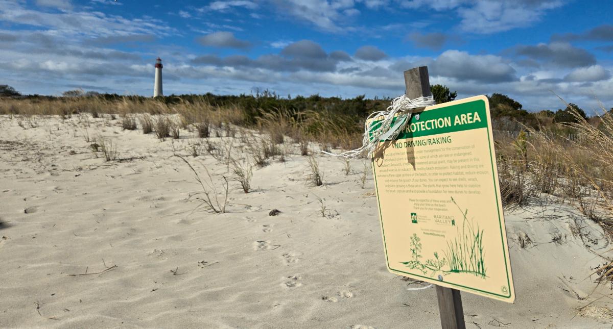
CSO Hosts Member Meeting in Cape May, NJ |
|
| Last week, the Coastal States Organization hosted its Fall Member Meeting in Cape May, NJ. Despite the number of challenges that Coastal Zone Management Programs have faced in the past year, CSO delegates shared a variety of program successes and discussed initiatives for the future of coastal resilience. As hosts, New Jersey’s Department of Environmental Protection shared some of the projects benefitting New Jersey’s coastal communities and environments. This included presentations on the Delaware Bay Restoration, the Shell Recycling Program, and the community-led Resilient NJ initiative. During the week, members took part in a field trip where NJDEP staff showcased some of the projects in Cape May that address storm vulnerabilities and restore coastal habitats. At a beach recently battered by a nor’easter, staff from the Office of Coastal Engineering discussed how New Jersey’s Shore Protection Program worked with municipalities to combat erosion on New Jersey’s beaches. Members also visited the Cape May Point Arts and Science Center, where they heard presentations on Cape May’s coastal history and the monarch butterfly migration. To end the day, the group traveled to South Cape May Meadows to explore the Nature Conservancy’s preserve and see the efforts TNC and its partners are making to support local flora and fauna. The Fall meeting brought together CZM programs and partners both in the conference room and in the field and displayed how CZMPs help America’s coasts respond to the present and prepare for the future. |
|
| In the States and Territories |
|
| Retired Barge Enhances Artificial Reef off Georgia Coast The Coastal Resources Division (CRD) of the Georgia Department of Natural Resources on Tuesday, Oct. 21, 2025, deployed a 130-foot retired barge to Artificial Reef A, located approximately seven nautical miles east of Little Cumberland Island in about 40 feet of water. The barge now rests on the seafloor, where it will soon begin serving as essential fish habitat, providing shelter and structure for a wide variety of marine life, including snapper, grouper, sea bass, and other reef-associated species. “Artificial reefs like this one play a critical role in supporting Georgia’s coastal fisheries,” said Paul Medders, CRD’s Habitat Enhancement and Restoration Unit lead. “They not only improve fish habitat but also create exciting new opportunities for anglers and divers.” Artificial Reef A is one of more than 30 permitted reef sites managed by CRD off Georgia’s coast. Read more here. Rhode Island – $2.3 Million NOAA Grant to Fund Removal of Toxic Debris Below Point Street Bridge The toxic remnants of an out-of-use Providence swing bridge are finally coming down with the help of a $2.34 million federal grant. The Point Street Bridge funding, awarded through NOAA’s Marine Debris program, will cover the cost for the Rhode Island Coastal Resources Management Council, along with The Nature Conservancy, to remove 250 tons of toxic and hazardous wooden timbers, pilings and sub-surface debris from the 1927 bridge. At this time, the bridge remains passable by motorists but has not swung open since 1959. However, the creosote wooden timber system used to lift the bridge was never removed. Its deterioration has caused pollution of the Providence River. Rhode Island’s project was one of 13 nationwide awarded a combined $26.4 million through NOAA’s Marine Debris program, which also helps to remove derelict vessels and abandoned fishing gear. Read more here. |
| Texas – Galveston Starts Coastal Erosion Project A restoration project to address coastal erosion on Galveston’s west end begins this week, closing off the Hershey Beach access point through the end of the year. In collaboration with the Galveston Park Board of Trustees, U.S. Army Corps of Engineers, and Texas General Land Office, the project is a landmark initiative to minimize the effects of coastal erosion on the west end of the island, according to the city’s website. Preparations began on October 6th with several weeks of work scheduled for the installation of pipelines needed to set materials in place, including renourishing approximately 1.8 miles of beachfront – from Sunbather Lane to 11-Mile Road – with dredged sand from the Galveston Ship Channel. The effort addresses the roughly seven feet of coastal erosion that develops annually on the island, particularly on the west end. “This project is essential to protecting our shoreline, homes, and infrastructure,” said Brian Maxwell, Galveston’s city manager. Read more here. How the Alabama Beach Mouse Protects Shoreline The Alabama beach mouse, a tiny, nocturnal mammal that burrows beneath the dunes of Baldwin County’s coast, plays an outsized role in keeping Alabama’s shoreline alive. While often out of sight, these small creatures act as natural engineers, dispersing seeds and stabilizing sand that protects communities from erosion and storm damage. “Overall, the Alabama beach mouse is a good indicator species,” said Trent Farris, environmental biologist with Volkert, who manages population studies at Gulf State Park. “Its presence signals the overall health of the fragile dune ecosystem.” Since its federal listing as endangered in 1985, the species has been a focus of state and federal recovery programs, with partners including the Alabama Department of Conservation and Natural Resources. Human activity, from development to foot traffic on dunes, can destroy habitat or fragment it into isolated patches. Storms pose perhaps the most unpredictable threat. Hurricanes, including Ivan, Katrina, Sally and Helene, have at times devastated coastal habitat, destroying vegetation that provides both food and shelter. Read more here. |
| Initiative for Resilient Great Lakes Coasts Expands Support with New Projects Across the Region The Initiative for Resilient Great Lakes Coasts (IRGLC), a partnership between the Great Lakes and St. Lawrence Cities Initiative and the NOAA Office of Coastal Management, funded by the Great Lakes Restoration Initiative, announced a new round of projects advancing through the program. These projects will help shoreline communities design and implement nature-based solutions to strengthen coastal resilience, protect vital public spaces, and restore critical habitat across the Great Lakes basin. Since its launch, IRGLC has supported over 25 projects with technical assistance, stakeholder engagement, and community-driven design. Several of the newest projects are now moving into advanced stages of engineering and design, protecting vulnerable shorelines from erosion and flooding while improving habitat and recreation access. This fall, IRGLC expanded to include communities in the Lake Erie and Lake Ontario basins, including the Niagara River. Read more about the projects here. Wisconsin – Door and Kewaunee Counties Receive $120,000+ in Coastal Grants Several projects in Door and Kewaunee counties will receive critical state funding through grants administered by Wisconsin’s Coastal Management Program. Five projects specific to Door and Kewaunee counties will receive $120,620 in grant funding, while hundreds of thousands more could impact them. In Door County, the Door County Soil & Water Conservation Department received $25,800 to address the spread of terrestrial invasive species along the Lake Michigan shoreline through public outreach and workshops for residents through partnerships with Wild Ones and the City of Sturgeon Bay. In Kewaunee County, the City of Kewaunee will develop a habitat restoration plan for the city-owned marshland, 65 acres of an 810-acre wetland at the mouth of the Kewaunee River, with its $27,800 grant. Both counties will benefit from a $23,272 grant for the Wisconsin Geological and Natural History Survey to calibrate and test a geologically realistic numerical groundwater flow model and develop a water-table map and a map of groundwater recharge values for southern Door and Kewaunee counties. Read more here. |
| Oregon – King Tides Bring Visitors, Opportunities for Scientists, Land Planners The king tides return to the Oregon Coast annually and while these highest tides of the year can cause flooding, erosion, and impacts to buildings and roads, especially during storms, they offer opportunities for scientists and land planners. King tides occur when the sun, moon, and Earth align, producing unusually high tides. This winter’s first king tide series begins November 5 to 7. For the past 15 years, Oregon has contributed to this international citizen science effort. Supported by the Oregon Coastal Management Program (OCMP), the CoastWatch Program of the Oregon Shores Conservation Coalition, and partners like the Oregon Coast Visitors Association and Oregon Sea Grant, this project is managed by OCMP in collaboration with coastal local governments, state and federal agencies, and other interested parties to manage, conserve, and develop Oregon’s coastal and ocean resources. Even a small rise in sea levels could make winter storms worse and make Oregon’s beaches narrower and harder to access. Read more here. California – State Revives Plans for Hollister Ranch Beach Access, Seeks Public Opinion State officials are asking for public input on how to provide beach access through Hollister Ranch, reviving a decades-old planning effort for one of California’s most restricted stretches of coastline. The Hollister Ranch Public Access Program (HRPAP) released a planning update in September outlining the next phase of a decades-long effort to establish land-based access to six public beaches along 8.5 miles of the Gaviota Coast. The beaches lie within the 14,400-acre Hollister Ranch subdivision, a private, gated community west of Gaviota State Park. Guided by the California Coastal Commission, California Coastal Conservancy, State Lands Commission, and California State Parks, the program will review access options such as trails, shuttles and limited vehicle entry, with public input being collected through a series of open-house workshops in November. The Hollister Ranch beaches remain one of the most inaccessible stretches of California’s coast, according to the Coastal Commission and state lawmakers. Currently, the only way to legally reach the beaches is via the Pacific Ocean. Read more here. |
| [NEW] Funding Opportunity: Great Lakes Restoration Community Grant Program The Great Lakes Restoration Community Grant Program (GLRCGP) application is now open! The program’s primary goal is to fund restoration projects in Great Lakes communities with environmental concerns in support of GLRI objectives and offer technical assistance and minimize administrative challenges associated with applying for and managing federal grant funds. Cities, states, Tribes and nonprofit organizations representing Great Lakes communities can apply directly to the Great Lakes Restoration Community Grant Program. The submission deadline for Letters of Intent is January 16, 2026. Learn more here. [NEW] Partnership Efforts and New Resources to Support BUDM Through its Coastal Zone Initiative to increase coastal habitat restoration and Beneficial Use of Dredged Material (BUDM) for habitat restoration and resource protection in the US, Manomet Conservation Sciences has worked with the Coastal States Organization and numerous partners to advance BUDM project planning in partnership with the U.S. Army Corps of Engineers in Southeast states, develop case studies on coastal restoration projects, and deliver a series of technical webinars. Deliverables, recordings, and more information are available on the Coastal Zone Initiative webpage. [NEW] Coastal Accelerator Cohort Application Now Open The goal of this program is to build coastal climate resilience and meet coastal 30×30 goals in the Pacific region of the United States. Coastal Quest is looking to fund mid-stage nature-based solutions, such as coastal restoration or protection projects, that have already begun scoping, planning, and feasibility analysis–and to assist in moving those projects through planning to implementation as members of a Coastal Accelerator Cohort. In addition to funding, Coastal Quest is offering technical support to Coastal Accelerator Cohort members. This could include fundraising and long-term financing, project planning and permitting, building community support, developing key partnerships, refining communications tools, and other support as needed. If you are a community-based or non-profit organization, Tribe, tribal or indigenous group, or public agency working on multi-benefit coastal projects in the Pacific Region, this opportunity may be for you! The deadline to apply is Friday, November 21st, 2025. Learn more here. [NEW] Serious Games for Coastal and Marine Conservation, Management, and Adaptation So-called “serious games” are designed for purposes beyond just entertainment, and they can be a powerful tool for teaching, engaging stakeholders, conducting research, and evaluating public policy. OCTO’s The Skimmer newsletter has compiled information about role-playing/simulation games that allow players to experiment with coastal and marine conservation, management, and adaptation actions (or inaction) to improve understanding of how coastal and marine ecosystems – particularly resource users and human communities – work. This compilation of games is continually updated. If you have additional games for us to consider, please send relevant information to sarah@octogroup.org. We are specifically looking for games with a management or conservation component (i.e., not solely focused on species identification or ecology.) Thank you for your assistance! 2025 State of the Beach Report The Surfrider Foundation has released the 2025 State of the Beach Report. The report features nine case studies from beaches and coastal areas across the country, including successful coastal restoration in Queens, New York, community-driven planning to identify solutions on beaches experiencing some of the worst erosion rates along the North Shore of O’ahu, comprehensive policy changes to protect Oregon’s iconic beaches, and Surfrider’s gold standard managed retreat and coastal restoration project at Surfers’ Point in Ventura, California. Learn more here. Study: Bulkheads Lead to Salt Marsh Erosion Researchers found in a recent study that, over the long term, bulkhead structures have a “significant negative effect” on marsh habitat size. Using high-resolution imagery from 1981 of Carteret County’s Bogue and Back sounds and Newport and North rivers, the team measured the marsh extent, or total marsh area, at 45 sites with bulkheads and 45 natural sites, or those without the type of hardened structure. The 1981 measurements were then compared to the data from images collected in 1992, 2006 and 2013 of the same 90 sites. The study found that all 45 bulkhead sites experienced marsh shoreline erosion during the 32-year study period, with complete marsh loss at 11% of the sites with bulkheads. More than 80% of the 45 natural marsh control sites experienced shoreline erosion, but at seven sites, around 15%, the marsh shoreline accreted waterward. None of the control sites experienced complete marsh loss. Learn more here. Funding Opportunity: $1.45 Billion in Supplemental Economic Funding Available for Disaster Recovery The United States Economic Development Administration has announced the Notice of Funding Opportunity (NOFO) for its Fiscal Year (FY) 2025 Disaster Supplemental Grant Program. This program makes approximately $1.45 billion available to areas that received major disaster declarations in the calendar years 2023 and 2024 for economic recovery activities. Funds can support both construction and non-construction projects. State and local governments, Native tribes, higher education institutions, public or private non-profit organizations that work with local government, economic development organizations, and public-private partnerships for public infrastructure are eligible. The EDA will fund up to 80% of the project with higher percentages available for severely distressed applications and Tribal organizations. Applications are accepted on a rolling basis until funds are spent for Readiness and Implementation path projects, while Industry Transformation grants will be due March 3, 2026. For more information, contact Rania Campbell-Bussiere. Funding Opportunity: Fiscal Year 25 Community Assistance Program The Community Assistance Program – State Support Services Element (CAP-SSSE) program provides funding to states to provide technical assistance to communities in the National Flood Insurance Program (NFIP) and to evaluate community performance in implementing NFIP floodplain management activities. Designation, duties and responsibilities of State Coordinating Agencies are found in 44 CFR 60.25. These regulations identify the states commitment to the minimum floodplain management criteria and to demonstrate the capability and responsibility to implement the program. In this way, CAP-SSSE helps to; ensure that the flood loss reduction goals of the NFIP are met, build state and community floodplain management expertise and capability, and leverage state knowledge and expertise in working with their communities. Learn more here. |
|
| The views expressed in articles referenced here are those of the authors and do not represent or reflect the views of CSO. If you have a news item or job posting to include in future CSO Newsletters, please send an email to: ecrocco@coastalstates.org with a subject line: “Newsletter Content”. Please include the information to be considered in the body of the email. Please note: CSO reserves final decision regarding published newsletter content and may not use all information submitted. |
|
| Coastal States Organization | 50 F Street. NW, Suite 570, Washington, DC 20001 | 202-800-0580 | cso@coastalstates.org | www.coastalstates.org |
|
|
|
|